
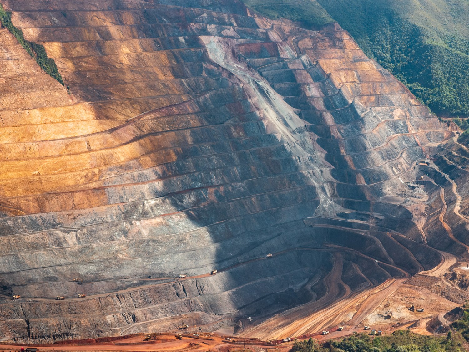
Varzea do Lopes mine, iron ore exploration, Gerdau mining company.
Júlia Pontés is the featured photographer
Júlia Pontés is a Brazilian-Argentinian Photographer, Visual Artist, storyteller, drone pilot, professor, and Mining Researcher whose work and research focus mainly on mining explorations and extractivist practices.
As a native of the Iron Quadrangle in Minas Gerais, Brazil, a region renowned for its vast mineral deposits, Júlia Pontés has a deeply personal connection to the mining industry. Since 2014, she has used performance, video, photography, and other media, including installation and sculpture, to shed light on the ecological and human rights violations of large-scale mining companies. Her work is a professional endeavor and a personal mission driven by a desire to communicate the challenges an extractivist-based society faces. This commitment to her cause is reflected in her deep community engagement and strong bonds with the people she works with.
She is a member of a group of Brazilian researchers studying the impact of mining on her home country. Her work is frequently displayed in collaboration with social movements, universities, and independent exhibition spaces to raise awareness of the impacts of extractive industries.
Júlia has a degree in Business Sciences from Sorbonne Paris I, specialized in Law and Economics at the Universidad Torcuato Di Tella in Argentina. She has a certificate in photography from the International Center of Photography (I.C.P.) in New York. She is a photography professor at Montclair State University in New Jersey and at Columbia University, where she received her M.F.A. in Visual Arts. She is also an Assistant Professor of Photography and Media at the University of Tennessee at Chattanooga.
Her mining visual survey has been recognized by the New York Foundation for the Arts, the National Geographic Society, Harvard University’s Planetary Health Alliance, Visura, The Current, Blue Earth Alliance, the Center for Santa Fe, Santa Fe Art Institute, and McColl Center. It has been exhibited and published in several international museums, galleries, academic publications, and media outlets in Brazil, Argentina, Spain, the U.S., France, Germany, Portugal, Uruguay, Slovakia, Austria, and Guatemala.
In 2022, she was awarded the prestigious Anonymous Was a Woman Environmental Grant and the Visura Grant for Visual Journalists. Dr. Alison Nordstrom also selected her work as the best portfolio in Fotofest 2022. The following year, Pontés received fiscal sponsorship from CENTER/Blue Earth Alliance and was part of the Climate Change residency cohort at the Santa Fe Art Institute. In 2024, Pontés joined the esteemed McColl Center’s residency as part of their Summer cohort.
Minas Gerais | Our Land, My Landscape
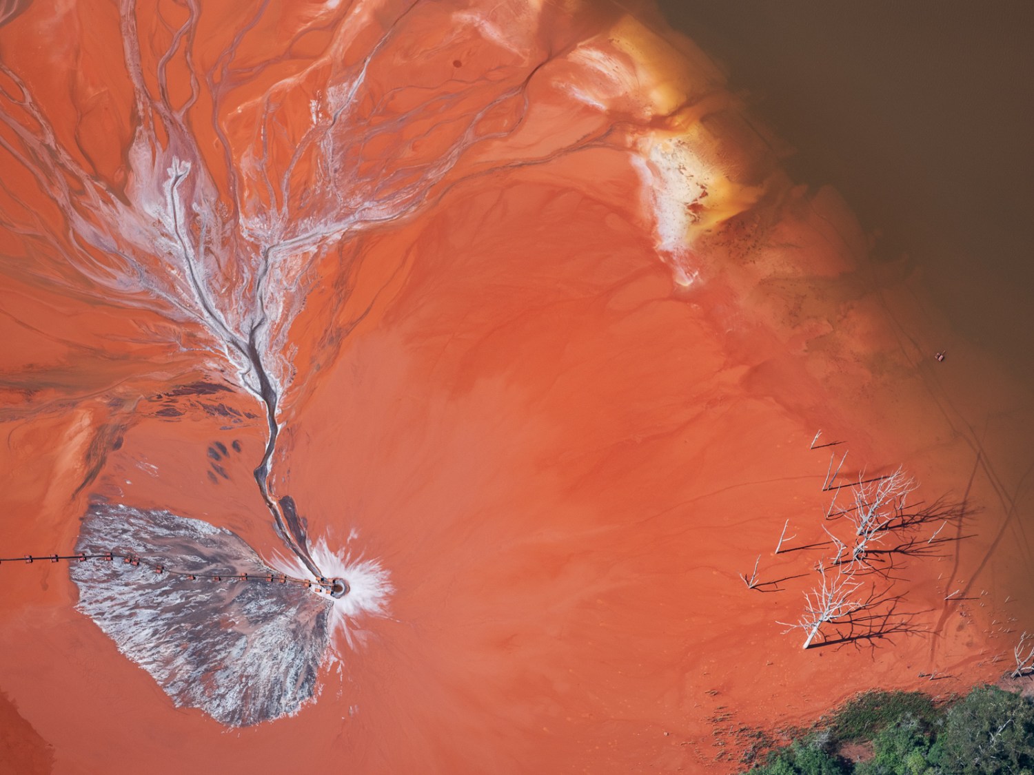
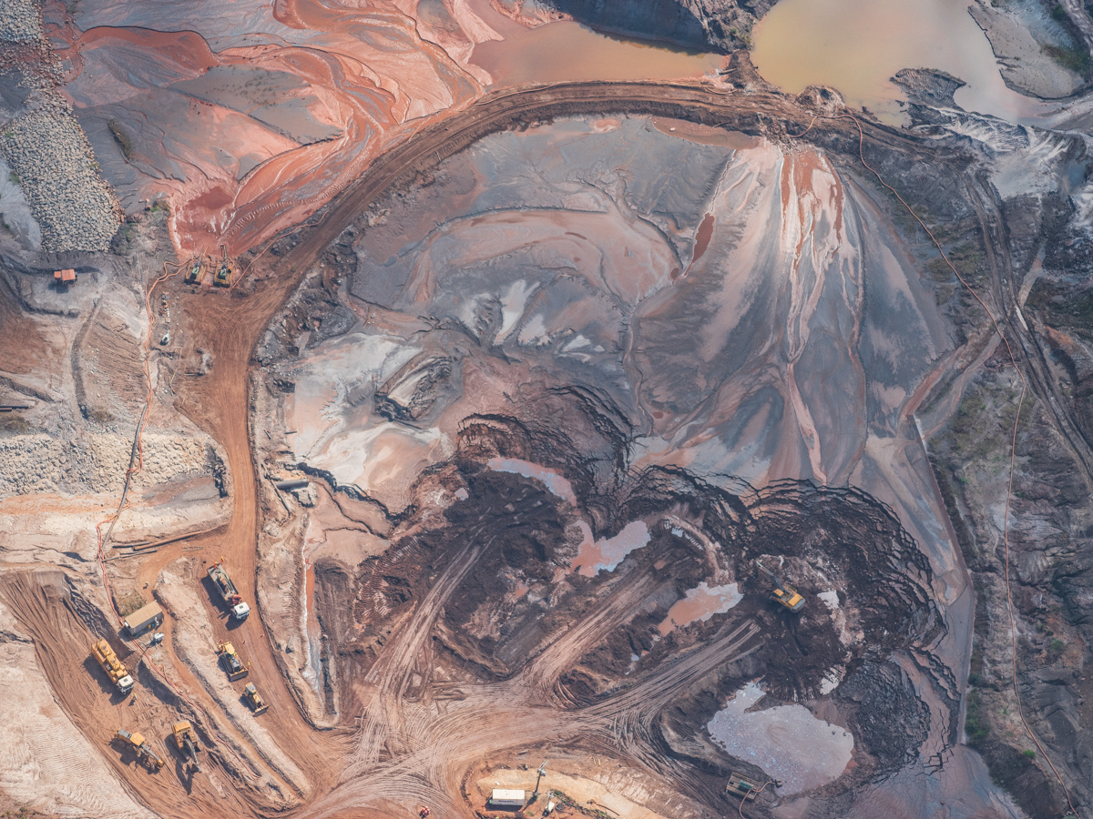
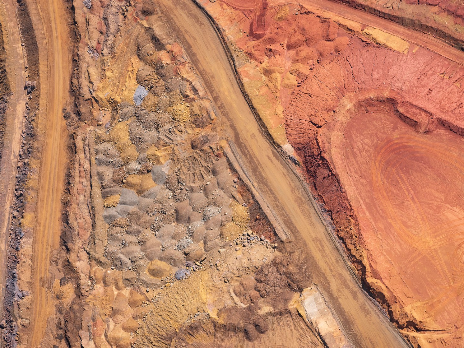
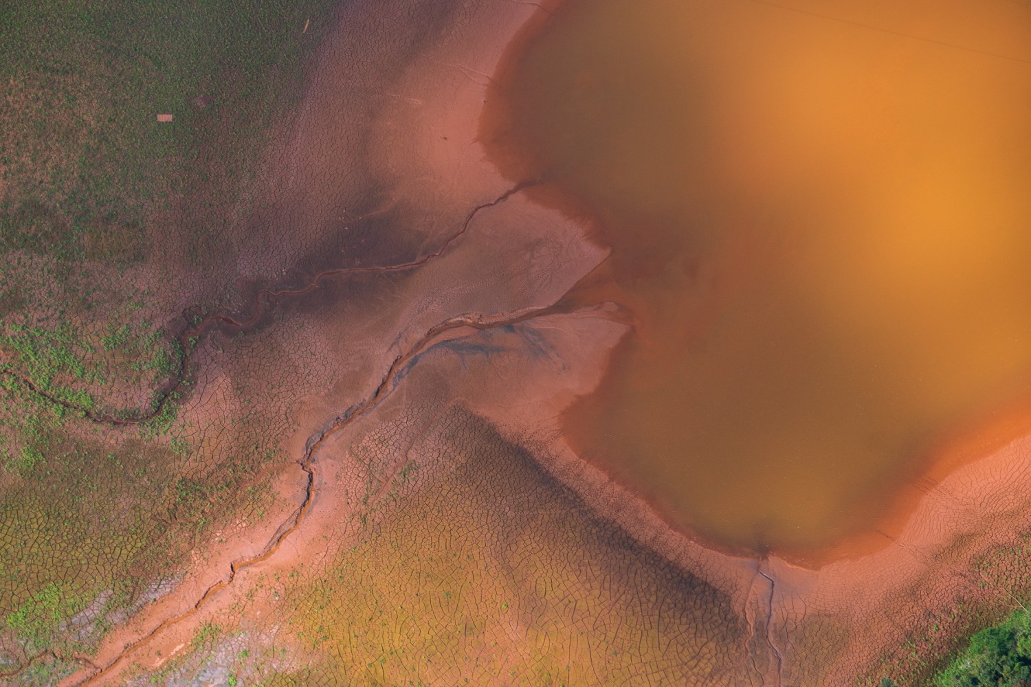
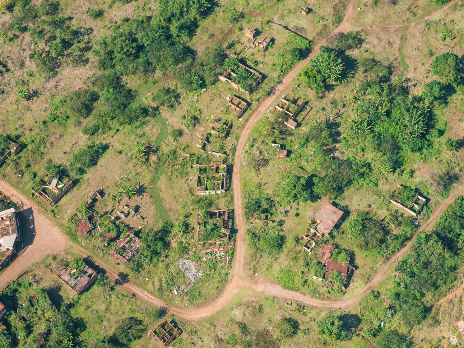
With the support of a pilot, I have been flying over various parts of the state of Minas Gerais and Góias since 2015. I document the visual scars left by mining in a region. Slicing the land with my camera, I aim to portray the radically transformed landscape. It took billions of years for the mountains to form and only a few centuries to destroy them. Initially, the objective was to document each orange point on the map, a task that proved almost impossible due to budget constraints. This documentation has since been carried out systematically but sporadically.
The initial objective was to document only on film to ensure the archive’s survival as a historical record. Still, it faced several technical challenges, and therefore, this was only partially accomplished. Documentation now covers a significant part of the large mines in Minas Gerais (I estimate around 70%) and is used as educational material by social movements and teachers.
In addition to the aerial documentation, I travel through different regions of the country, mostly on my own, recording families that connect with mining at different levels, trying to document the many nuances of this activity.
Throughout my career, I want to connect with other female photographers and community members in the world’s major mining regions and foster a broad dialogue of resistance.
Antônio Pereira, a district with a rich history spanning over three centuries, is a part of Ouro Preto. Its name is a tribute to the Portuguese explorer who set foot in the region around 1700, marking the beginning of the gold rush in Minas Gerais.
For more than 320 years, the region has been subject to the consequences of an alleged “mineral vocation” that left deep social and environmental scars. At first, mining relied on enslaved labor, and environmental racism in the area has never been addressed.
Since 2019, the Doutor Dam has been declared at risk of collapse. Since then, hundreds of people have suffered from evacuations, forceful displacement, and evictions from their homes.
The area is 5km (3miles) away from the Samarco mining company, the site of the catastrophic Fundão dam collapse in 2015, the largest environmental disaster in Brazil’s history, which had a profound negative impact on the region’s environment and its social tissue.
20 ° 17’23.38 “S 43 ° 29’52.31” W
Gongo Soco, a gold mine with a rich history, was discovered in 1745 on the lands of the Baron of Catas Altas. In 1825, the mining rights were sold to the Imperial Brazilian Mining Association, based in Cornwall, England, marking a significant chapter in the region’s history. In 1839, it was the largest gold mine in Brazil.
Today, the region houses several large-scale mineral projects, such as Apolo and Brucutu, and the Gongo Soco mine is now an iron ore mine. Still, according to the 2010 IBGE census, 36.3% of the population lives on up to 1/2 minimum wage.
Gongo Soco holds tailings (mining residue) dams upstream from local communities. On February 8, 2019, at 2:30 am, one of the two sirens near the four communities adjacent to the mine was activated. They were immediately evacuated due to an alleged imminent risk of the dam breaking.
More than seven years later, without any sign of a break, people are still prohibited from returning to their homes due to a court decision that lacks proof of actual risk. The region has a population of approximately 650 inhabitants, 485 of whom were evacuated in 2019, a significant part of whom have been linked to the area for over six generations. Mining licenses and mapping of mineral reserves indicate that its surrounding subsoil could be worth at least 60 billion dollars at current iron ore prices.
19°57’34.54”S 43°36’11.96”W
The word Itabirito originates from the Tupi-Guarani language family and means “rock that scribbles in red.”
It not only gives this mining town its name but is also the name of a reddish mineral with a lower iron content. It also lends its name to the city where mining is the main economic activity and where, in 2018, 70% of crimes were acts of violence against women.
According to the organization Justina sobre Trillos, in towns where large mining or infrastructure projects are established, including the illegal extraction of gold and precious stones, there is an influx of large numbers of men, a factor that puts women at risk and makes them vulnerable to human trafficking, prostitution, and sexual violence.
20°13’19.60″S 43°53’34.29″W
The tailings dam was constructed in 1974 and is today owned by the Indian company Hindalco.
In 2016, when Novelis still owned it, it announced the closure of its operations and put up for sale the lands that had been donated to the company by the municipality for job creation. After the closing measures to preserve the area, polluting part of the Tripui River, where the first nugget of Ouro Preto was found, and in 2016, toxic waste was found. Today, the processing plant is still in operation.
20 ° 23’55.56 “S 43 ° 32’46.95” W
Reconstruction work on the bottom of the site where the Fundão tailings dam used to be, 3 ½ years after its collapse. In 2015, the rupture of the Fundão dam released 40 billion gallons of toxic mud, overwhelming several towns throughout one of Brazil’s most important watersheds, the Rio Doce (Doce River). Up until today, it is considered the most significant environmental accident in the country’s history.
It killed 19 people and overwhelmed several towns and indigenous communities throughout the Rio Doce basin, which affected an estimated over 2 million people. Until today, in 2026, its legal compensation has still not been achieved.
20°12’28.09″S 43°27’39.05″W
Usiminas is one of the largest steel producers in the Americas. According to Fitch Ratings in 2024, the company accounts for 35% of Brazil’s total steel market share. The Usiminas industrial complex is the largest plain-steel complex in Latin America and one of the top 20 in the world.
However, according to the news outlet Brasil de Fato, Usiminas’ largest production plant in another Minas Gerais city, Ipatinga, faced a judicial mandate in 2019 to reduce its “dust emissions,” which were 56 times above permitted levels.
A request filed by the Public Ministry of Labor (MPT) says that Usiminas releases into the air a “large volume of gases and sedimentary particles, which pollute the environment, including the workplace, exposing the population and workers to the risk of contracting diseases, especially of the respiratory system.”
20° 9’40.42″S 44°27’44.33″W
On January 25, 2019, at the same mine, the adjacent B1 tailings dam’s slope collapsed, costing 279 lives.
40% of the town’s population, scattered over different communities, remained isolated for over 3 months. Determining the extent of the human and environmental damage caused by this criminal tragedy is impossible.
Vale, responsible for this and most of the mining tailings dams in Brazil at imminent risk of collapse, is one of the largest mining companies in the world and has yet to respond appropriately to its criminal responsibilities in the Corrego do Feijão and Samarco dam collapses.
20°7’4.01″S 44°7’27.63″W
The rupture of the dam from Samarco-Fundão killed 19 people in 2015 and overwhelmed several towns, the first of which was Bento Rodrigues. Until today, it is considered the largest environmental tragedy in Brazil’s history.
20°14’10.21″S 43°25’9.54″W
Dona Alice received a minimal financial reward for allowing part of the world’s largest ore pipeline to pass through the land where she had lived with her family for 50 years. The pipeline made it impossible for them to plant deep-rooted crops, vibrated with the flow of ore, causing cracks in the walls, and silted up the springs, leaving the family without access to water.
In 2013, for months, the family endured part of the ore construction project in their backyard, without water due to the silting up of the springs that supplied it, while caring for her terminally ill husband. Once completed, the ore pipeline, which ran through what was their land, made it impossible for the family to plant any food with deep roots; its vibration accentuated the cracks in the walls around their house.
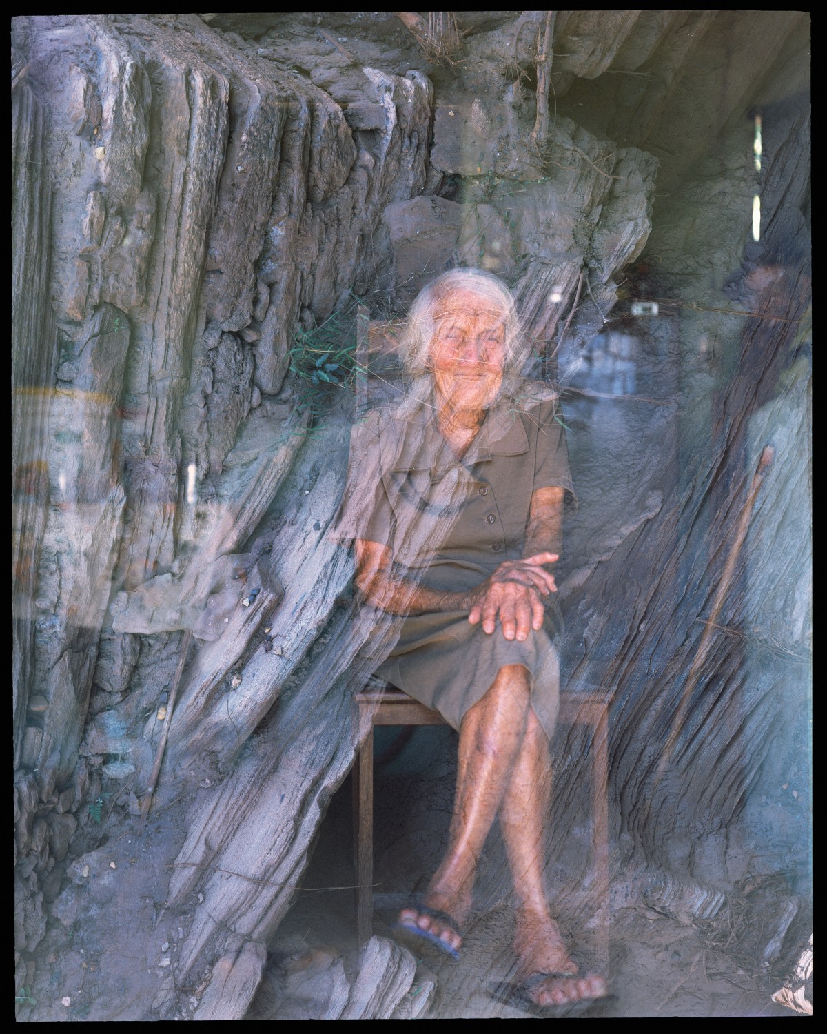
Dona Saninha, 2016, at 106 years old, double-exposed with an image from a section of the Rio Doce, in Mariana, Minas Gerais, Brazil, corroded by mud released by the 2015 Fundão Tailing collapse.
Dona Saninha was born in Água Quente, a rural area of Conceição do Mato Dentro, Minas Gerais, Brazil, which was deeply affected by the adjacent mining complex owned by Anglo American.
Água Quente had its springs of the nearby rivers silted up by the mining company, and the tailings dam contaminated the stream that cuts through the community. The community depends on water trucks for its water supply, and some families live with less water than the UN-recommended daily minimum.
In recent years, the community members, all descendants of Dona Saninha, were slowly displaced, relocating their residences to different locations; the community as such no longer exists.
To see more of Júlia’s work here.
La fotógrafa del mes es Júlia Pontés
Júlia Pontés é uma fotógrafa, artista visual, professora universitária e pesquisadora de mineração brasileira-argentina, cujo trabalho se concentra principalmente na documentação de explorações minerais e práticas extrativistas no Brasil e Estados Unidos.
Natural do Quadrilátero Ferrífero de Minas Gerais, Brasil, região conhecida por seus vastos depósitos minerais, Júlia tem uma grande conexão pessoal com a indústria da mineração que se expande a partir de sua própria historia familiar. Desde 2014, ela utiliza performance, vídeo, fotografia e outras mídias, como instalação e escultura, para lançar luz sobre as violações ecológicas e de direitos humanos cometidas por grandes empresas de mineração. Seu trabalho é uma missão pessoal, impulsionada pelo desejo de comunicar os desafios enfrentados por uma sociedade baseada no extrativismo. Esse compromisso se reflete em seu profundo engajamento comunitário e fortes laços com as pessoas com quem trabalha.
Ela faz parte de um grupo de pesquisadores brasileiros que estudam o impacto da mineração organizados pelo MAM- Movimento pela Soberania Popular na Mineração. Seu trabalho é frequentemente exibido em colaboração com movimentos sociais, universidades e espaços expositivos independentes para conscientizar sobre os impactos das indústrias extrativistas.
Júlia é formada em Ciências da Administração pela Sorbonne Paris I, pós graduada em Direito e Economia pela Universidade Torcuato di Tella, na Argentina. Possui certificado em fotografia pelo International Center of Photography (I.C.P.) de Nova York. É professora de fotografia na Montclair State University, em Nova Jersey, e na Universidade Columbia, onde obteve seu mestrado em Artes Visuais. Hoje é professora da Universidade do Tennessee em Chattanooga.
Sua pesquisa visual sobre mineração foi reconhecida pela New York Foundation for the Arts, pela National Geographic Society, pela Planetary Health Alliance da Universidade Harvard, pela Visura, The Current, pela Blue Earth Alliance, pelo Center Santa Fe, pelo Santa Fe Art Institute e pelo McColl Center. Foi exibido e publicado em diversos museus, galerias, publicações acadêmicas e veículos de comunicação internacionais no Brasil, Argentina, Uruguai, Espanha, Austria, França, Eslováquia, Alemanha, Portugal, Uruguai e Guatemala.
Em 2022, foi agraciada com a prestigiosa bolsa Anonymous was a Woman e com a bolsa Visura para Jornalistas Visuais. A Dra. Alison Nordstrom também selecionou seu trabalho como o melhor portfólio no Fotofest 2022. No ano seguinte, Pontés recebeu o patrocínio fiscal do CENTER/Blue Earth Alliance e fez parte do grupo de residência sobre Mudanças Climáticas no Santa Fe Art Institute. Em 2024, Pontés integrou o prestigiado programa de residência do McColl Center.
Ó Minas Gerais | Minha Terra, Nossa Paisagem
Com o apoio de um piloto, sobrevoo diversas partes do estado de Minas Gerais e Góias desde 2015. Documento as cicatrizes visuais que a mineração deixou na região, recortando o espaço com a câmera, busco retratar a paisagem radicalmente transformada, foram bilhões de anos para que as montanhas se formassem e apenas alguns séculos para destruí-las. Meu objetivo era documentar todos os conflitos ambientais de Minas Gerais, uma tarefa que se mostrou quase impossível devido às restrições orçamentárias. Desde então, essa documentação tem sido realizada de forma sistemática, porém esporádica.
O objetivo inicial era realizar a documentação apenas em filme, para que sobrevivesse como arquivo histórico. No entanto, enfrentou diversos desafios técnicos e, portanto, isso só foi parcialmente alcançado. A documentação agora abrange uma parte significativa das grandes minas de Minas Gerais (estimo cerca de 70%) e é utilizada como material educativo por movimentos sociais e professores.
Além da documentação aérea, viajo por diferentes regiões do país, principalmente sozinha, registrando famílias que são atravessadas pela mineração em diferentes níveis, tentando documentar as muitas nuances dessa atividade nas populações, na cultura e no meio ambiente. Ao longo da minha carreira quero conectar com outras fotógrafas e comunidades nas grandes regiões de mineração do mundo e poder criar um grande diálogo coletivo de resistência.
